Pedestrian City

Originally appears in the Summer 2012 issue
Statistics on our ever-urbanizing planet are well known and widely circulated: half of humanity currently lives in a city or town; by the year 2030, we will have 5 billion urban dwellers and nearly 40 megacities of 10 million or more; at the midpoint of the 21st century, 70% of the planet will call a city home.
Less hyped is the fact that one third of urban dwellers worldwide are children, many of whom live in poverty. While organizations like the United Nations and UNICEF are working towards getting children onto the urban agenda as important stakeholders [i], schools have been slow to adopt urban education as part of the curriculum. Few formal educational opportunities exist for children to study how we build, plan, govern, and live optimally in cities. If part of our job as educators is to prepare students to be globally-minded and locally-engaged citizens of the future world they will sustain and lead, urban issues must be part of the conversation in the classroom of the 21st century.
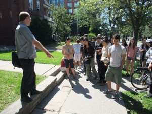
Walking is the most basic mode of urban transportation we all share, a phenomenon aptly described by architect Jan Gehl in the 2011 film Urbanized: “Cultural circumstances may differ, economic circumstances may differ, climatic circumstances may differ, but basically we are the same little walking animal.” Walking is also critical to sustainable urban design since neighbourhoods that prioritize pedestrian use make for economically, environmentally, and socially vital places. These factors make a study of walking an obvious jumping-off point for an authentic discussion of sustainable urban transportation and design at the middle or secondary school level.
The following three learning activities focus on “walkability” and are designed to get students to think about, describe, and sharpen their ideas about what walking means as a mode of transport. These lessons are accessible to any teacher and can be delivered in just about any context without prior knowledge or additional resources. The first two learning activities are described broadly with a selection of teaching procedures, while the third learning activity, a creative mapping exercise, is described in detail with handouts and exemplars as appendices.
To view the photo-rich magazine version, click here.
If you are not already a subscriber, please subscribe to read the full article
Josh Fullan is the creator of Maximum City and a teacher at the University of Toronto Schools, an independent grade 7-12 school affiliated with the university. Content in this module is based on an expert presentation during the summer 2011 pilot program by Dylan Reid of Spacing Magazine.
Leave a Reply
You must be logged in to post a comment.


