Stormwater Stewards

Originally appears in the Winter 2013-2014 issue
Stormwater is quickly becoming one of the greatest sources of urban pollution. Yet most of the public are unaware of this growing threat. Stormwater is part of the hydrological cycle wherein most rainwater and snowmelt infiltrates the ground. Within urban areas, an increasing percentage of it becomes surface runoff, which mobilizes contaminants that either flow directly into surface waterways or is channeled into sewers.
Storm Water Green Streets (SGSs), a type of Low Impact Development (LID), are now being used by municipalities and developers to mitigate water quality (i.e. contaminants) and quantity (i.e. runoff) threats. These are small excavated areas backfilled with a topsoil mixture of highly-permeable sandy soil with organic matter and are designed to maximize infiltration, pollutant retention, and vegetative growth. They perform similar functions as mitigation ponds, rain gardens, planter boxes, eco-roofs and swales. Portland, Oregon is among the cities with the greatest number and density of SGSs. But even here, public education and the maintenance of these facilities have proved challenges to their successful use.
In this article, we present in-depth and hands-on stormwater curricula which has been used successfully by many Portland teachers. It is our hope that educators interested in hydrology, urban ecology and engineering solutions to environmental problems will replicate or modify it for their use. It may be particularly useful for educators with stormwater mitigation sites on or near their school site.
Our ten-week inquiry aims to increase students’ environmental literacy, specifically their knowledge, dispositions and skills, and to teach students relevant ecological principles to urban and natural hydrology. It also provides students with engineering and field research skills, while developing a personal sense of stewardship. In what follows, you will find the key questions, along with a detailed description of the main activities of the inquiry.
Question: Why is stormwater becoming one of the greatest sources of pollution in urban areas?
Students use their own words to describe the big picture of how urbanization has decreased stormwater quality and why field work, such as testing water quality and habitat restoration, are effective mitigation tools.
Students should tour their own schoolyard and make observations about the structure and possible functions of existing SGSs. (If none exist there, visit the nearest example in the local community.) Have them compare and contrast the soil and plants found in the SGS to those found in wetland and forested areas. Then discuss why these facilities are being used instead of pipes (i.e. they are usually more cost effective). Students can then identify the primary functions of these facilities—lowering runoff and pollutant retention—and how their maintenance will help maintain these functions.
In a jigsaw activity, separate students into three groups entitled habitat (SGS soil and vegetation), field work (SGS maintenance), and stormwater (from pollutant to resource). These themes represent the stewardship (field work) necessary to maintaining a well-functioning watershed (habitat) which effectively removes pollutants from runoff (stormwater). Give ten pictures to each group and ask them to arrange them from good to bad (i.e. picture of pristine stream to picture of polluted storm water). Students will quickly get into discussions—sometimes arguments—over which pictures are good or bad. Have a representative from each of the three groups form a discussion group to answer questions such as “What makes this stormwater polluted?” or “What makes good habitat?” At the end students should ideally be able to answer the question “How does good field work result in good habitat and stormwater?” and to define “good stormwater stewardship”.
Question: How do water, soil and plant properties relate to stormwater processes?
Water: Students can learn about the water cycle by drawing the larger urban area in which they live, school grounds with SGS’s, or a nearby forested area on large butcher paper. They then identify the stormwater segment of this cycle, and where it starts and ends. They also note the differences between natural and urbanized water pathways and how this distinction relates to their lives. They also learn about water cohesion and adhesion, through the exercise of determining how many water drops they can place on a penny and nickel, and how this relates to how stormwater transports pollution.
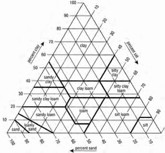
Soil: Students learn about soil texture, bulk density and horizons as they relate to stormwater infiltration. Allow students to use the feel method to determine the texture of samples of sand, topsoil, and clay. Have them draw the soil triangle on butcher paper, and place the identified samples on their given textures. Students can then calculate the bulk density (mass of soil/volume of container). One of the easiest methods is to excavate a small hole in the ground (1 gal), weigh the soil to attain mass, place a plastic bag over the hole, fill hole with water till level with grade, pour plastic bag of water into measuring device to attain volume. Students can hypothesize how a change in bulk density might affect porosity (% voids in soil) and thus infiltration (next paragraph). Similarly, students can determine horizon A depths in the school yard and SGSs, and hypothesize how the greater A depth may affect stormwater flow. This can easily be done by inserting a soil auger into the soil, extracting the core, and then examining the soil core visually (i.e. color change from dark brown topsoil to light brown subsoil) and through the feel method of forming soil ribbons in one’s hand.
Hydrology: Students learn how to calculate rain volume through the following simulation. Pour water through a small bin with holes onto a surface with many cups that catch the rain. After the “rainfall” ends, have students average the height of water found in the cups and extrapolate this amount to the entire area to get the total volume of rain fallen. This is an effective way to teach how replication can increase the accuracy of measuring rain volume.
Plants: Ask students to discuss how large plants provide an environment which cleans storm water more than small plants. They can also learn how to estimate plant percent using a simulated random sampling activity in class. Lay down a map (or anything with patchily distributed shapes), lay down a ruler parallel to the map (either N-S or E-W, 0 in value on map corner), cast a die, locate number on ruler, lay another ruler perpendicular to the one already on the map on this number (0 in value of second ruler on die cast number), cast die again, locate number on second ruler (your now on the map), lay a white square transect (1 in x 1 in) on that second number, , and record percent cover of vegetation.(on copies of figure 3?)
Question: How do SGSs mitigate harmful effects of stormwater in urban areas?
Differences Among Field Sites:
In order for students to understand how the ecology and hydrology of different systems can affect stormwater quality, have students visit natural areas and record:
- Plant diversity and percent cover
- Soil texture
- Bulk density
- Horizon A depth
- Infiltration rate
- Water quality (pH, temperature, dissolved oxygen, and turbidity)
Ideally data from a forest, an urban wetland site and an on-site SGS should be compared. This allows students to investigate how local ecology affects stormwater across natural and urban settings and evaluate if SGS sites are affecting the stormwater.
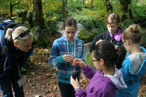
Split the class into four different sampling groups: water quality, infiltration, plants and soil. The water quality group gathers temperature, dissolved oxygen, turbidity and pH data using a Hach water quality kit. The infiltration group uses a single ring infiltrometer (a 3-gallon metal paint bucket with the bottom cut out can work in most soils), pours 1-gallon of water into the ring, measures the time it takes for water to completely infiltrate the soil and repeat until a steady infiltration rate is reached .
The soil group digs a small hole (about 2 fists deep and wide), dries soil in the classroom and uses a balance scale to determine weight of the removed soil. Prior to returning the soil to the hole, students lay a plastic bag in the hole, pour water from a graduated cylinder into the hole and record volume of water. Soil weight is divided by volume to get bulk density. Extending this, students can also calculate porosity (ɸ=1-(bulk density/2.65g/cm3). Both of these metrics can be a good measure of soil compaction which greatly affects infiltration rates and runoff. Soil horizons and texture should be measured with the use of a soil auger and ‘feel method’, respectively. Students can determine what soil texture existed at their sites to a good degree of accuracy with minimal training and supporting feel method guides which are abundant online. Soil augers cost less than $100.
Plant diversity is measured along a transect with students laying out a 100 metre measuring tape, randomly selecting a number between 1-100, laying down a 1 m square quadrat on that selected number, identifying plant species and calculating percent cover for each species. The quadrat is constructed of 1 inch diameter PVC pipe and 4 plastic elbow fittings. Vegetation types could include: shrubs, herbs, grasses and trees.
Combine data from all of these groups for individual and whole class analysis, with groups of 5-6 students making posters that display their findings. Students compare data between urban and natural sites and qualify parameters such as water quality or infiltration rates as good, okay or poor. Students can also make conclusions regarding the efficacy of the school’s on-site SGS and whether it is functioning more like a natural or urban system, using the same rating scale in their evaluation.
School Storm Water Budget
In order for students to evaluate how water moves through an urban landscape, students can perform a superficial water budget of the school property. The water budget is superficial in that it does not address groundwater in or out, evapotranspiration or change in storage, but it is still a useful exercise. In order to estimate this volume, students should multiply nearby online rain gauge data times the area of the school. Next, students measure how much of the school’s property surface is impervious and pervious. From these totals, students can make hypotheses regarding how much rain water runoff entered the city’s stormwater infrastructure and how much water infiltrated into the soil. Students may then revise their hypotheses based on further explorations. For example, they might determine that much of the impervious surfaces on the school’s campus direct stormwater into on-site SGSs. From this, new water budgets can be created which reflect actual runoff rates from the school’s property. Have students translate these water volume values (ft3) into tangible representations such as number of basketballs or automobiles so that they and others will better appreciate the water volumes involved. Students can then see how much water moves through the school’s property and estimate how much water is being removed from the municipal storm water system by the presence of the SGSs.
Home Water Budget and SGS Design
This final activity allows students to plan for ways that they and their families can be ‘stormwater stewards.’ Students print out two copies of an aerial photo of where they live, including apartment buildings, typical urban residential settings and large urban lots. Using the first copy, have students perform a water budget for the most recent month on their property, similar to the school storm water budget. They will indicate where impervious areas are located, and how water moves from the roofs to different surfaces. They will note any gutters, whether downspouts directly flow into the municipal stormwater system, and where water from the driveway flows. Using the second copy of the aerial image, ask students to redesign their properties to include LIDs such as eco-roofs, rain gardens, pervious pavement and bioswales. After completing their new designs, ask them to recalculate their home water budgets and again translate water volume values into tangible representations.
Prior to this lesson, it would be helpful to invite local storm water educators to provide a lesson that teaches students how LIDs function to soak up storm water in a cost-effective manner. A possible extension activity could include having students calculate the cost to redesign their residence, or collect data on their property, such as infiltration rates or vegetation diversity.
Assessment
Learning Gains and Changes in Attitude: Before and after participating in the program, students’ interest in science and their attitudes towards the environment should be assessed against a control group not participating in the program. No formal formative assessment of knowledge need be used. Instead, have students each complete a workbook throughout the unit.
Conclusion
The stormwater stewards curriculum teaches students about the strategies employed by municipalities, citizens and NGOs to address non-point sources of water pollution and improve watershed health. In the process students learn their own impacts and the science behind of these strategies, including soils, hydrology, plants and engineering. Inspired by the hands-on curriculum, we have seen students internalize new knowledge and become confident in their skills to improve watershed health. Many become stewards of their own watersheds and begin educating their parents.
The authors would like to thank the following for assisting with the creation and implementation of this curriculum: National Science Foundation GK-12 program, Portland Public Schools, Portland’s Bureau of Environmental Services and several dedicated individuals. To view the curriculum, which will be available in early 2014, visit http://www.pdx.edu/soe-gk12/curriculum
Notes
See http://www.pdx.edu/soe-gk12/videos-and-mini-documentaries and view Bioswales at Mt Tabor Middle School, Portland for a video describing this project.
To view the photo-rich magazine version, click here.
Steven M. Braun and Ted Hart are students in the School of the Environment at Portland State University, where they are both pursuing PhDs in Earth, Environment and Society. Steve’s research involves restoration ecology and environmental education, whereas Ted’s interests involve storm water bio-retention facility functions and education. Kirk Ordway is a science educator at Mt. Tabor Middle School in Portland Public Schools.
Leave a Reply
You must be logged in to post a comment.


